Cheadle and Gatley Lib Dems are moving
Graham, Tom and Ian
Your Lib Dem team for Cheadle West & Gatley Learn more
What were the local issues four decades ago?
Cheadle and Gatley Lib Dems are moving
Cheadle and Gatley Lib Dems are moving
What were the local issues four decades ago?
Cheadle and Gatley Lib Dems are moving
Stockport’s mapping revolution
by Lib Dem team on 22 December, 2014
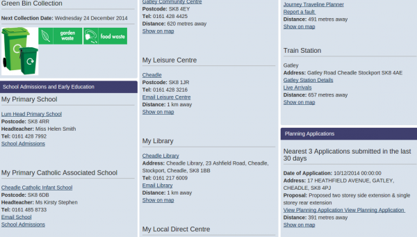
Stockport Council has launched a great new service, allowing us all to see a huge amount of information overlaid on a map of the borough.
Put in your road or postcode from the front page of the Stockport website and find out a host of useful information from your bin collection days and councillors to your local schools, health centre, leisure centre, park, library, optician, pharmacy, doctor, dentist, hospital, planning applications and more.
There’s a mapping function covering the whole borough. You can find out almost anything. The map below shows land the Council owns along with adopted highways (i.e. pavement and road the council is responsible for maintaining) together.
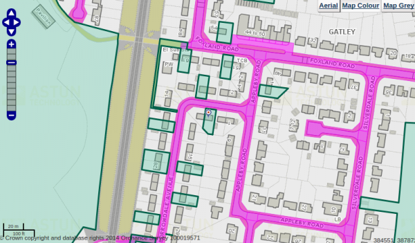
Council owned land (in cyan) and adopted highways (in magenta)
Here are just some of the other things you can see on the map:
- Ward, constituency and borough boundaries and location of polling stations
- Citizens advice bureaux, job centres, libraries, community toilets, CCTV locations, police stations and cemeteries
- Council buildings and schools
- Green belt, smoke control and air quality management areas
- Grounds maintenance (what’s maintained and who does it)
- Dentists, doctors, hospitals, opticians and pharmacies
- Listed buildings and conservation areas
- Land owned by the Council, and Council-owned land leased to others
- Planning applications
- Recycling centres
- Retirement and sheltered housing schemes
- Leisure centres, museums, galleries and parks
- Stockport Homes properties and offices
- Definitive rights of way, train stations, public car parks and bus stops
- Adopted highways, streetlights, illuminated bollards, illuminated signs, highway structures and safety inspection routes
- Winter gritting routes for roads and footways, grit bin locations
- Trees with tree preservation orders
This is a new service – there will be the odd bug so please let us know if you spot anything that doesn’t work correctly.
7 Comments
Excellent work, however even better if it was a little interactive – in the sense that if you could report faulty lights directly from this site etc…
You can’t quite do that yet, Shabs (soon I hope) but you can already report fault via the map from the stockport.gov.uk front page. Just go to report a streetlight, and click on the faulty light. If a lamp’s already been reported it shows up as red.
I like it.
Can blocked / reported drains and Highway Gullies be listed on here too please?
Why can’t these be reported on line?
What is happening about the Highway Gullies on Hall Street?
Hi John,
You can report blocked gullies online at http://www.stockport.gov.uk/doitonline/az/blockedgullies?view=Standard (and via the front page of the council website).
I’ll pass on the request about listing them all on the map.
I know the gullies on Hall Street are visited – I don’t have specifics but I’ll chase it up.
Can you point me to the actual definitive rights of way please, with Footpath and Bridleway numbers on it. this should be legally available and I can’t find it anywhere.
thanks
Hi Christine, the best person to contact is Stockport’s Public Rights of Way officer Ernest Nama (ernest.nama@stocport.gov.uk). He may be away right now but he’ll be able to help.